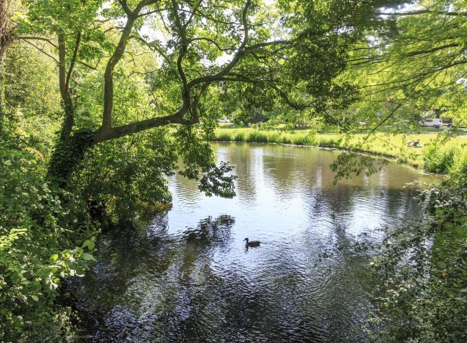
There’s a lovely nine-kilometre path that runs along the bank of the Leidsche Rijn from Utrecht Centraal Station to Terwijde Station. This canalised river was once an important part of the infrastructure, but it’s now a great place to relax and enjoy the boats, bridges and farms along its banks. And the Vinex vibe…
By Sarah-Mie Luyckx, photo by Jurjen Drenth
It’s actually a bit too soon to start this walk at Smakkelaarsveld, as the area to the north of the station is still one big building site. If things go according to plan, next year this field will have morphed into Smakkelaarspark with three residential blocks in a green setting, and later on, the water of the Leidsche Rijn. The chaotic sea of bikes, where many of us swore and cursed while searching for our two-wheelers, will be wiped from our collective memory. And no-one will remember that until the late 19th century, this used to be an inland harbour.
Eccentric squire
We walk under the railway to Westplein. In another couple of years, the Leidsche Rijn will flow here again too. At the moment, you can’t see it until you’ve crossed the square to Leidseweg. This section of the Oude Rijn River was canalised in the 17th century. Canalisation means straightening the course of a river and making it deeper so that it is more easily navigable. Walking along the right-hand bank, you cross the friendly Molen De Ster, a reminder of the busy industrial area that used to be here. Don’t forget to wave at the pigs, Bella and Beer, as you pass. When we reach the neoclassical Rijksmuntgebouw, we will be in one of the loveliest parts of Utrecht. Turn right after the bridge where the Leidsche Rijn and the Merwede canal briefly touch lips, and then left into Oog in Al park. This used to be part of a country estate built on the Leidsche Rijn. In 1664, the eccentric squire Everard Meijster (known as the Mad Squire) took it over so that he could keep an eye on expansion plans for the city. Hence the name Oog in Al, which roughly translates as ‘Beady Eye’.
Ships & sheep
To the right of the park, there’s an avenue named after the squire which leads to the Dafne Schippersbrug, a bridge over the Amsterdam-Rijn canal. We go in a southerly direction on the boulevard opposite towards the former municipality of Vleuten-De Meern. This municipality was swallowed up by Utrecht when it built the mega Vinex housing estate called Leidsche Rijn, named after the canal that cuts straight through it. Nowadays, you can relax on the canal bank on a sunny day and watch the freight ships on Verthorenkade. Passing the Aanvoerder pumping station, with a meeting place for youth specially designed from weathering steel, we go under the Rhijnoord viaduct. If you ignore the zoom of the motorway, you suddenly find yourself plunged into idyllic village life. You see the Leidsche Rijn flowing along Rijksstraatweg, characteristic old farms and on the opposite side, Park Voorn with its herd of peacefully grazing sheep. The park belongs to the pretty white townhouse opposite the Stadsdambrug. Cross the bridge and continue along Zandweg until you see J&B Grijpers on the opposite bank. Turn right onto the bike path. This is Langerak: the first housing estate in Leidsche Rijn, where the initial pioneers staked their claim some 23 years ago. Even diehard fans of the historical inner city have to admit that this neighbourhood has been tastefully designed. It is spacious, green and the architecture is varied.
Swings
After crossing Langerakbaan, we walk straight ahead in front of Groenedijk, behind the playground. You find yourself in authentic Dutch landscape here, with knotted willows lining the road and beautiful traditional old buildings. Turn left in front of Park Hoge Weide, which owes its name to a few solid green humps, a great panorama and a fun swing park. Then it’s a bit of a trek across Groenedijk, where you’ll see the odd original country house dotted among the newly built homes. You can turn right onto Johanniterpad, or carry on for a few hundred metres to Castellum Hoge Woerd. The archaeology museum has the contours of the Roman fort that stood here 2,000 years ago. The top attraction is an ancient wooden ship that was found 3 kilometres further along. There is also an urban farm and café. We continue through Parkwijk via Johanniterpad. Turn left into Pauwoogvlinder at the somewhat bare Groot Zandveld, cross ’t Zand and turn right onto the bike path parallel to the road. This takes us to Terwijde station, where you can take the mainline train back to Utrecht Centraal.